
 1 week ago
12
1 week ago
12
The new road is part of the Chinese drive to ramp up infrastructure development in occupied Kashmir north of Siachen.
 team reveal that the basic trail of the road was laid between June and August last year.")
Satellite images captured by the European Space Agency and reviewed by India Today’s Open-Source Intelligence (OSINT) team reveal that the basic trail of the road was laid between June and August last year.

New Delhi,UPDATED: Apr 25, 2024 16:46 IST
In a development that could have security implications for India, China is building a concrete road in a part of illegally occupied Kashmir close to the Siachen Glacier – touted as the world’s highest battlefield, satellite pictures show.
The road in Shaksgam Valley, a part of Pakistan-occupied-Kashmir (PoK) ceded to China in 1963, branches out from an extension of Highway G219 in China’s Xinjiang and disappears into mountains at a place (coordinate: 36.114783°, 76.671051°) approximately 50 km north of India’s northernmost point, Indira Col in Siachen Glacier – a forward area visited by Defence Minister Rajnath two times since March.
Satellite images captured by the European Space Agency and reviewed by India Today’s Open-Source Intelligence (OSINT) team reveal that the basic trail of the road was laid between June and August last year. 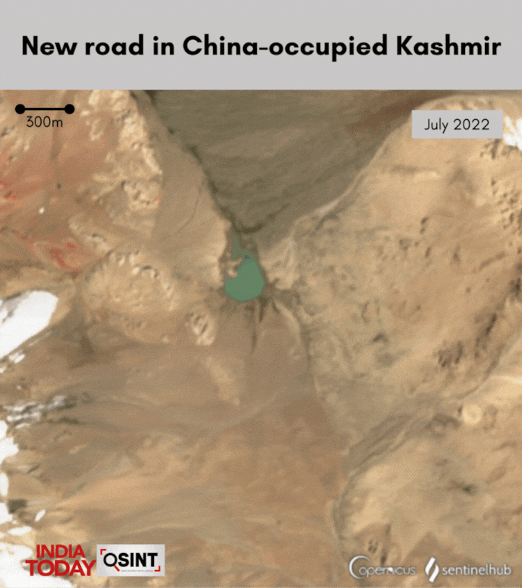
“This road is totally illegal and India must register its diplomatic protest with the Chinese,” says Lt Gen Rakesh Sharma, the former commander of Indian Army’s Fire and Fury Corps that is responsible for manning Kargil, Siachin Glacier, and Eastern Ladakh.
The construction was first flagged by an observer of the Indo-Tibetan frontier who calls himself ‘Nature Desai’ on X (formerly Twitter).
Thread:
In a significant development, ðèð³ road has breached the border at Aghil Pass (4805 m) and entered the lower Shaksgam valley of Kashmir, ð®ð³ with the road-head now less than 30 miles from ð®ð³ Siachen
This permanently answers the question of Shaksgam for ð®ð³
1/4 pic.twitter.com/TyjMcUqz2S — Nature Desai (@NatureDesai) April 21, 2024
WHY IT MATTERS
The road lies in the Trans-Karakoram Tract – a region historically part of Kashmir and claimed by India. The latest official map published by the Union government after the abrogation of Article 370, continues to show this region as Indian territory.
The tract, spread over about 5,300 square kilometers, was captured by Pakistan in the 1947 war and handed over to China as part of their bilateral boundary agreement signed in 1963 – which is not recognised by India.
Indian defence experts have long argued that any change in the status quo in this part of occupied Kashmir amounts to a violation of India’s sovereignty and territorial integrity. There are also concerns that more such infrastructure projects could threaten the existing security scenario in this mountainous region.
India’s concerns are also driven by reports of greater military cooperation in the region. In 2021, Pakistan’s Gilgit-Baltistan province announced plans for a new road connecting Muzaffarabad to Mustagh Pass which sits on the Pakistan border with Shaksgam Valley. As per the report, it would be linked to Yarkand in Xinjiang – indicating that the road might pass through the Shaksgam Valley to connect with China’s national highway G219. 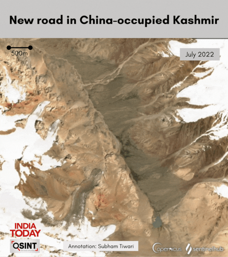
Many observers like Lt Gen Sharma, however, believe that the Chinese roads in Shaksgam Valley could primarily be meant for transporting minerals, especially Uranium, allegedly mined from Gilgit Baltistan – to Xinjiang. Nonetheless, he advises constant vigil against the potential use of these roads for “military maneuvers” by the armies of Pakistan and China.
The road enters the contested region at Aghil Pass, which has historically served as a frontier of Kashmir with Tibet – something that Chinese rulers had recognised in the past.
Aghil Pass and the Shaksgam Valley repeatedly appear in the text presented by the Indian side in support of its claim during border negotiations with China before the 1962 war.
“The official maps of the Government of India, including the one attached to the 1907 edition of the Imperial Gazetteer of India and the political maps published by the Survey of India showed this area in Indian territory,” the Indian side led by then MEA director for China affairs, JS Mehta told China’s foreign office in Beijing in June 1960.
“Official Chinese maps published in 1917, 1919, and 1923 also showed this area as a part of India,” reads the archive of the Ministry of External Affairs uploaded on the website of renowned tibetologist Claude Arpi.
GOVERNMENT'S STANCE
In parliament, the government has repeatedly reiterated India’s commitment to take back all areas of Pakistan-occupied-Kashmir (PoK), which India considers Shaksgam Valley a part of.
“I want to put this on record that whenever I say the state of Jammu & Kashmir in the House, then both PoK and Aksai Chin are part of it. The boundaries of Jammu and Kashmir decided in our Constitution, and also in the Constitution of Jammu and Kashmir, include PoK and Aksai Chin,” Home Minister Amit Shah told parliamentarians in 2019. “I am ready to give my life for this,” he had roared.
BILATERAL UNDERSTANDING ON BORDER AREAS
Despite decades-long control, the Chinse occupation of the area lacks political legitimacy. Article 6 of the 1963 Boundary Agreement between China and Pakistan gives China only temporary control of the area – until the Kashmir issue is resolved.
“The two Parties have agreed that after the settlement of the Kashmir dispute between Pakistan and India, the sovereign authority concerned will reopen negotiations with the Government of the People's Republic of China, on the boundaryâæ so as to sign a formal Boundary Treaty to replace the present agreement,” it reads.
While India’s engagement with Pakistan on the Line of Control (LoC) is governed by the 1972 Shimla Agreement, there is no such agreement with Chinese authorities about the Shaksgam Valley.
INDIAN PROTESTS
China built a metalled road between 2017 and 2018 in lower Shaksgam Valley, west of strategic Karakoram Pass. Reports also talk of the presence of Chinese military infrastructure in the Valley, which was reportedly protested by Indian military officials during border talks in 2022 that were held following the deadly Galwan Valley clashes in 2020.
Last year, India also lodged strong diplomatic protests with Beijing for showing Aksai Chin plateau as its official territory. In 2015, External Affairs Minister Dr S Jaishankar said the country had protested the Chinese plans to invest $46 billion into a China-Pakistan economic corridor.
Published By:
Ashutosh Acharya
Published On:
Apr 25, 2024


 English (US) ·